Showing posts with label Southeast Lighthouses. Show all posts

Wednesday, January 4, 2012

A Light on January 4th

Point Pinos by Gerald C. Hill, from forthcoming California & Hawaii Lighthouses: Illustrated Map & Guide.

On January 4, 1856, Charlotte Layton became the first official female head lighthouse keeper on the West Coast. She was appointed to the job at Point Pinos, CA, held by her late husband, which she'd been doing for some months--along with caring for their four children. Charles Layton had died the previous November, after being shot as part of a sheriff's posse that tried to capture outlaw Anastacio Garcia. (Garcia was arrested in October 1856 and lynched in the Monterey jail four months later by his "friends.") Charlotte married her assistant keeper in 1860, whereupon they traded jobs. They were gone by 1863.

From Morris Island Lighthouse, SC (then known as Charleston Light-station):
The keeper further reports that a light shock of earthquake occurred on January 4, 1887, at 6:45 a. m., of about twenty seconds duration, accompanied by the usual rumbling noise. It had, apparently, a horizontal motion. It was pretty well felt in the town, but did no damage.
From the Annual Report of the Light-House Board for the Fiscal Year Ended June 30, 1899 (note the chain of transmission!):
...Congress authorized that C. K. Marr and E. H. Pierce, keepers of the Cuckolds, Maine, fog-signal station, accept each a silver watch awarded to them, respectively, by the government of the Dominion of Canada, in recognition of their services in rescuing the captain and crew of the schooner Aurora, of Harboursville, Nova Scotia, on January 4, 1896.

The watches were forwarded to the State Department by the British Government, which transmitted them through the Treasury Department to the Light-House Board, by which they were delivered through the inspector of the First light-house district to the specified lightkeepers, and their receipts for the watches were transmitted to the government of the Dominion of Canada through the same channels.

Tuesday, November 22, 2011

Early 19c U.S. Lighthouses: The Original Tallies

In the course of doing research for our lighthouse maps, we came across widely varying estimates as to the number of lighthouses in early 19th century America. Which to believe?

We were stumped. Then after months of exhaustive Googling, we hit the jackpot: THE AMERICAN STATE PAPERS: Documents, Legislative and Executive of the Congress of the United States, from the First Session of the First to the Third Session of the Thirteenth Congress, Inclusive: Commencing March 3, 1789, and Ending March 3, 1815.

Above: Sandy Hook, NJ (1764), the oldest standing U.S. lighthouse. Illustration by Peter M. Mason, from Mid-Atlantic Lighthouses: Illustrated Map & Guide.

From an 1804 report in THE AMERICAN STATE PAPERS:
Our own Government has attended to the erection of light houses, with a vigilant eye. Already their number on our extended sea coast amounts to thirty-one...
Those lighthouses, listed north to south, were in a statement "shewing" expenses:
New Hampshire: Portsmouth; Massachusetts: Boston, Nantucket, Nantucket Beacon, Cape Roge [Cape Pogue], Thatcher's Island, Plum Island, Plymouth, Seguin Island [now in Maine], Baker's Island, Cape Cod, Wigwam Point [Annisquam], Gayhead; Rhode Island: Newport; Connecticut: New London, Faulkner's Island, Lynde's Point; New York: Montauk, Sandy Hook, Eaton's Neck; Delaware: Cape Henlopen; Virginia: Cape Henry, Smith's Point, Old Point Comfort; North Carolina: Cape Fear, Cape Hatteras, Shell Castle [off Ocracoke Island]; South Carolina: Charleston, George Town; Georgia: Tybee.
In 1811 Winslow Lewis won a contract to outfit all U.S. lighthouses with his patented lighting system, which was a cheap imitation of the Argand system used in Europe (an example of the need for international copyright protection). He listed 45--in no discernible order, whether geographical, alphabetical or financial:

New Bedford
Gay Head
Cape Page [Cape Pogue]
Nantucket
Chatham, 2 lights
Cape Cod
Plymouth, 2 lights
Boston
Baker Island, 2 lights
Cape Ann
Wigwam Point
Newburyport, 2 lights
Portsmouth
Portland
Seguin
Franklin Island
West Quoddy
Scituate
Whitehead
St. Simonds
Sapelo Island
Charleston, S.C.
Georgetown, S.C.

Cape Fear
Cape Lookout
Cape Henry
Cape Hatteras
New Point Comfort
Old Point Comfort
Smith’s Point
Cape Henlopen
Sandy Hook
Montauk Point
Little Gull Island
Eaton’s Neck
New London
Faulkner’s Island
Lynde Point
Five Mile Point
Fair Weather Point
Watch Hill
Newport
Point Judith
Tybee
Wood Island

Monday, September 5, 2011

Civil War Lighthouse Report

Lighthouses were key to protecting and controlling shipping, hence they were of vital strategic importance in the Civil War. Confederates dismantled or sabotaged many lighthouses to keep them out of Union hands, with varying success.

Per the 1863 Journal of the Franklin Institute: "this wicked rebellion has extinguished 125 lights [out of 556], many of them of the highest importance."

Below are some noteworthy excerpts from a "report of the operations and condition of the light-house establishment for the fiscal year ending June 30, 1863" submitted to the Secretary of the Treasury:
In the fifth light-house district, embracing the coasts from Metomkin inlet, Virginia, to New River inlet, North Carolina, including Chesapeake bay and tributaries, Albemarle and Pamplico sounds, circumstances have not permitted the board to make many improvements...

The new illuminating apparatus ordered for Cape Hatteras main light, combining the latest and highest improvements, has been placed in its position
....

The light-houses at Roanoke marshes, northwest point of Royal Shoal, Croatan, Cape Lookout, and Ocracoke [NC] have been refitted and the lights re-exhibited.

The light-house at Wade's Point [NC] was also re-established, but early in May last it was visited by a guerilla force from the main land and again destroyed....

The light-houses at Craney Island shoal, Back river, and Cape Henry [VA] have been repaired, renovated, and refitted, and are now in operation, the important light at Cape Henry being protected from the enemy by a military guard detailed by the general commanding at Fortress Monroe....

A new fog-bell, frame, and machinery has been placed at Old Point Comfort light-house, and extensive general repairs made at that station....

The light-vessels in this district have received careful attention, and with but one or two exceptions have remained securely at their stations. The light-vessel built under contract for Frying Pan shoals, off Cape Fear, North Carolina, has been sent to her station, but the lights have not been exhibited in compliance with the wishes of the naval authorities....

In the sixth light-house district, embracing the coasts from New River inlet, North Carolina, to Cape Canaveral light-house, Florida, inclusive, the same reason which called for a brief summary of operations in the last annual report still exists, i.e., the slow recovery of the territory by the United States military forces.

Congress, at its last session, having made an appropriation for the establishment of range lights to facilitate the entrance into Port Royal harbor, early measures were adopted to secure the designed end. The necessary preliminary examinations were made, the plans and estimates of the engineer approved, and the construction of the buildings completed at Portland, Maine.

When ready they were sent out to Port Royal and put up. These ranges consist of two lights on Hilton Head island, one light on Bay Point, and a light-vessel anchored on Fishing Rip. Through the courtesy of the general commanding the United States forces at Port Royal, the necessary details of soldiers were made to assist in opening a vista through the woods for the inner range on Hilton Head, and by the kindness of the admiral commanding the South Atlantic Gulf squadron, a suitable vessel for Fishing Rip was placed at the disposal of the board. These lights have been completed and lighted, to the great benefit of the increasing commerce seeking that port.

Early in the year a competent engineer was sent to this district to make, as far as possible, a detailed examination into the condition of the light-houses, &c., on this coast, and the damage done by the enemy thereto. He performed the duty confided to him with marked promptitude and ability, and his report conveys the intelligence that the following named lights have been more or less completely destroyed:
  • St. Helena sound [SC] light-house, blown up.
  • Hunting Island [SC], undermined and thrown down.
  • Combahee Bank [SC] light-vessel, removed and burnt.
  • St. Simon's Island [GA] light-house, blown up.
  • Wolf Island [GA] beacons, blown up.
He reported the almost total destruction or removal of the buoys by the enemy, and a large number of suitable sizes and kinds, with the necessary accessories, was promptly forwarded from the buoy depots of the north. Upon their arrival at Port Royal [SC; captured in 1861] they were, as far as required, placed in position under the direction of the officers of the Coast Survey on duty on that station.

In addition to the light-vessel for Fishing Rip [Port Royal Sound, SC], placed at the service of the board, the kindness of Admiral DuPont secured the services of a small schooner, a prize to the naval forces, as a tender for the district. She has been officered, manned, and placed in commission, and has proved of the greatest possible assistance in the performance of various works in the district, such as buoyage, transporting materials, supplies, &c.

The seventh light-house district embraces the coast of Florida from St. Augustine to Egmont key. The lights in this district have been maintained in useful operation.

Cape Florida light has not been re-exhibited. The necessary materials for its repair, and a suitable illuminating apparatus to replace the one destroyed by the enemy, have been provided and stored at Key West, so that the work may be prosecuted to early completion whenever it may be found safe and prudent to do so.

The eighth and ninth light-house districts have received the especial attention of the board, and in view of the many serious difficulties to be overcome in the re-establishment of the various aids to navigation, it has reason to congratulate itself upon having accomplished so much.

The important light at Pensacola has been repaired and re-exhibited, showing temporarily a fourth order, instead of the first order lens, which is allotted to that station, and the placing of which is not deemed advisable until the occupancy of a greater portion of the surrounding country by the United States forces shall have placed the station beyond risk of damage and spoliation.

Extensive repairs to the light-house at Ship island [MS] (whose re-establishment was stated in the last annual report) have been made, and further needful renovations are in progress.

The screw-pile structure at Merrill's Shell Bank [Pass Marianne, LA] was found in measurably good condition. A new illuminating apparatus was provided, the necessary repairs made, and the light re-exhibited.

Pleasanton's island [LA] light-house has been repaired, refitted temporarily, and the light exhibited.
West Rigolets light-house [LA] has been repaired temporarily, and the light reestablished.

The light-houses at Port Pontchartrain, Bayou St. John, and New Canal [LA] have been refitted and the lights put into operation.

Pass à 1'Outre [LA] light-house has been thoroughly repaired, a new keeper's dwelling erected, and the light exhibited.

The old light-house at the head of the Passes [LA] was burned at the commencement of the rebellion. A new structure has been erected, and the light shown.

South Pass and Southwest Pass lights [LA] have been renovated, extensive repairs being made to the latter, and the lights re-exhibited.
Illustration: Price's Creek, NC, lighthouse ruin by Gerald C. Hill, from Southeast Lighthouses Illustrated Map & Guide.

Friday, June 11, 2010

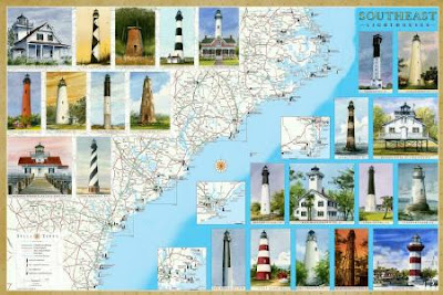
New Lighthouse Maps Cover the Southeast Coast from North Carolina to Florida

We're pleased to announce our latest maps and guides to Lighthouses: Florida and Southeast. The Southeast map covers North Carolina, including the Outer Banks, South Carolina and Georgia.

Between them, the two maps locate and describe all the standing and lost lighthouses along about 2000 miles of the Atlantic and Gulf coasts.

In addition to the detailed cartography, each map features original watercolor illustrations, descriptions and history of every lighthouse, along with directions to the lighthouses or the best viewing spots.

The maps include directories of lighthouse and maritime museums, ferries, sightseeing cruises and flights.

They are available as folded maps to guide you in your travels, and as laminated posters.

Ask for them at book stores, gift and museum shops in the region. They are also available online from amazon.com (search Bella Terra Maps).