Showing posts with label North Carolina Lighthouses. Show all posts

Tuesday, November 22, 2011

Early 19c U.S. Lighthouses: The Original Tallies

In the course of doing research for our lighthouse maps, we came across widely varying estimates as to the number of lighthouses in early 19th century America. Which to believe?

We were stumped. Then after months of exhaustive Googling, we hit the jackpot: THE AMERICAN STATE PAPERS: Documents, Legislative and Executive of the Congress of the United States, from the First Session of the First to the Third Session of the Thirteenth Congress, Inclusive: Commencing March 3, 1789, and Ending March 3, 1815.

Above: Sandy Hook, NJ (1764), the oldest standing U.S. lighthouse. Illustration by Peter M. Mason, from Mid-Atlantic Lighthouses: Illustrated Map & Guide.

From an 1804 report in THE AMERICAN STATE PAPERS:
Our own Government has attended to the erection of light houses, with a vigilant eye. Already their number on our extended sea coast amounts to thirty-one...
Those lighthouses, listed north to south, were in a statement "shewing" expenses:
New Hampshire: Portsmouth; Massachusetts: Boston, Nantucket, Nantucket Beacon, Cape Roge [Cape Pogue], Thatcher's Island, Plum Island, Plymouth, Seguin Island [now in Maine], Baker's Island, Cape Cod, Wigwam Point [Annisquam], Gayhead; Rhode Island: Newport; Connecticut: New London, Faulkner's Island, Lynde's Point; New York: Montauk, Sandy Hook, Eaton's Neck; Delaware: Cape Henlopen; Virginia: Cape Henry, Smith's Point, Old Point Comfort; North Carolina: Cape Fear, Cape Hatteras, Shell Castle [off Ocracoke Island]; South Carolina: Charleston, George Town; Georgia: Tybee.
In 1811 Winslow Lewis won a contract to outfit all U.S. lighthouses with his patented lighting system, which was a cheap imitation of the Argand system used in Europe (an example of the need for international copyright protection). He listed 45--in no discernible order, whether geographical, alphabetical or financial:

New Bedford
Gay Head
Cape Page [Cape Pogue]
Nantucket
Chatham, 2 lights
Cape Cod
Plymouth, 2 lights
Boston
Baker Island, 2 lights
Cape Ann
Wigwam Point
Newburyport, 2 lights
Portsmouth
Portland
Seguin
Franklin Island
West Quoddy
Scituate
Whitehead
St. Simonds
Sapelo Island
Charleston, S.C.
Georgetown, S.C.

Cape Fear
Cape Lookout
Cape Henry
Cape Hatteras
New Point Comfort
Old Point Comfort
Smith’s Point
Cape Henlopen
Sandy Hook
Montauk Point
Little Gull Island
Eaton’s Neck
New London
Faulkner’s Island
Lynde Point
Five Mile Point
Fair Weather Point
Watch Hill
Newport
Point Judith
Tybee
Wood Island

Sunday, October 16, 2011

Lights Kept Burning in the Civil War

From National Almanac and Annual Record for the Year 1864:

NOTICE TO MARINERS.
All the lights on the coast of the United States from Cape Henry, Virginia (entrance to Chesapeake Bay), to the Rio Grande, Texas, except those at Naval Hospital (Norfolk), Craney Island Shoal, Cape Hatteras and Beacon, Ocracoke, Cape Lookout, N.W. Point, Royal Shoal, Roanoke Marshes, Brant Island Shoal Light-Vessel, Long Shoal Light-Vessel, Croatan Light-House, Wade’s Point Light-House, Martin’s Industry Light-Vessel, Carysfort Reef, Dry Bank, Sand Key, Key West, Dry Tortugas, Pensacola, Ship Island, Chandeleur Island, Merrill’s Shell Bank, Pleasanton’s Island, West Rigolets, Port Pontchartrain, New Canal, Pass à L’Outre, South Pass, Head of Passes, and Southwest Pass, have been extinguished or destroyed by lawless persons during the past year, but will be relighted as soon as practicable after being repossessed by the Government. The lights above named are now in operation.
TREASURY DEPARTMENT,
Office Light-House Board, Washington City,

July 1, 1863.

Illustration: Pensacola Light (FL) by Gerald C. Hill, from United States Lighthouses Illustrated Map & Guide.

Friday, September 2, 2011

All in a Day's Work for the Lighthouse Service

A hurricane hit the Outer Banks of North Carolina on Sept. 2 & 3, 1913.

With the damage inflicted by Hurricane Irene fresh in our minds, below are some noteworthy excerpts from the Lighthouse Service Annual Report of 1914.

Illustration: Ocracoke Island Light by Gerald C. Hill, from Southeast Lighthouses Illustrated Map & Guide.

SAVING OF LIFE AND PROPERTY BY VESSELS OR EMPLOYEES OF THE LIGHTHOUSE SERVICE
DURING THE FISCAL YEAR 1914

Vessel or employee rendering service.

Nature of assistance.

Tillman F. Smith, keeper, Washington, N.C., lighthouse depot.

Saved buoys from going adrift from lighthouse depot in storm.

Daniel T. Paul, laborer in charge, Rumley Marsh Light, N.C.

Recovered lighthouse property after a storm.

Robert H. Bertram, master, Light Vessel No. 80.

Kept light displayed on light vessel with proper characteristics during storm.

Mumford Guynn, keeper, and James O. Casey, assistant keeper, Pamlico Point Light Station, N,C.

Ditto.

Wesley Austin, keeper, Ocracoke Light Station, N.C.

Saved the Government property in his charge and gave shelter to the residents of Ocracoke Island during storm.

John T. Shipp, keeper, and Thomas Quidley, assistant keeper, Neuse River Light Station, N.C.

Saved the Government property in their charge during storm.

Alexander T. Loss, mate, and crew of Light Vessel No. 71. [Stationed at hazardous Diamond Shoal, off Cape Hatteras, torpedoed by a German submarine in 1918.]

Kept light vessel near her station during storm.

Herbert R. Brownley, first officer, tender Juniper.

Rendered assistance to 3 men on board the power boat which had become disabled near Beaufort Inlet, N.C.

Tender Maple, Thomas J. Miles, commanding.

Took wrecked schooner in tow and beached her on Cedar Point, Md.

Randolph Scarborough, master, Light Vessel No. 80 and crew.

Efficient service in handling light vessel and quickly returning her to station after she had parted moorings in hurricane.


Friday, June 11, 2010

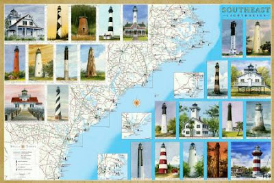
New Lighthouse Maps Cover the Southeast Coast from North Carolina to Florida

We're pleased to announce our latest maps and guides to Lighthouses: Florida and Southeast. The Southeast map covers North Carolina, including the Outer Banks, South Carolina and Georgia.

Between them, the two maps locate and describe all the standing and lost lighthouses along about 2000 miles of the Atlantic and Gulf coasts.

In addition to the detailed cartography, each map features original watercolor illustrations, descriptions and history of every lighthouse, along with directions to the lighthouses or the best viewing spots.

The maps include directories of lighthouse and maritime museums, ferries, sightseeing cruises and flights.

They are available as folded maps to guide you in your travels, and as laminated posters.

Ask for them at book stores, gift and museum shops in the region. They are also available online from amazon.com (search Bella Terra Maps).