
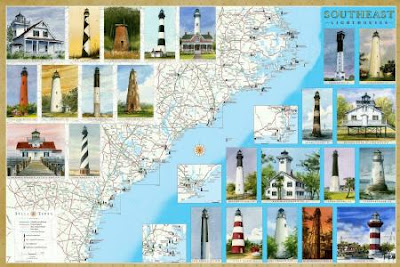
 We're pleased to announce our latest maps and guides to Lighthouses: Florida and Southeast. The Southeast map covers North Carolina, including the Outer Banks, South Carolina and Georgia.
 Between them, the two maps locate and describe all the standing and lost lighthouses along about 2000 miles of the Atlantic and Gulf coasts.
In addition to the detailed cartography, each map features original watercolor illustrations, descriptions and history of every lighthouse, along with directions to the lighthouses or the best viewing spots.
 The maps include directories of lighthouse and maritime museums, ferries, sightseeing cruises and flights.
They are available as folded maps to guide you in your travels, and as laminated posters.
Ask for them at book stores, gift and museum shops in the region. They are also available online from amazon.com (search Bella Terra Maps).


No comments:
Post a Comment