Showing posts with label Bella Terra news. Show all posts

Tuesday, June 12, 2012

Our First Award! TOURMAP 2012

United States Lighthouses Illustrated Map & Guide won a special award at TOURMAP Festival 2012, in Prague, Czech Republic.
We are thrilled to announce our first-ever prize!

TOURMAP Festival 2012 chose from almost 600 international entries to award the Prix President to our United States Lighthouses Illustrated Map & Guide. We were sad that we couldn't travel to Prague to pick up the sleek crystal award in person on May 18. However the US Ambassador stood in--and then forwarded it to us (see photo above). Read the TOURMAP press release (scroll down).

It takes a village of creativity to make an illustrated map. Kudos to our talented artists, cartographers and designer!

Saturday, November 27, 2010

New Northwest Lighthouses Map & Guide

Our newly redesigned and revised Northwest Lighthouses Map & Guide is available.

Coming to shops in Oregon, Washington and Alaska, and available now from amazon.com.


Retailers: Contact us for information on how to stock it!

Friday, June 11, 2010

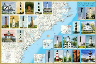
New Lighthouse Maps Cover the Southeast Coast from North Carolina to Florida

We're pleased to announce our latest maps and guides to Lighthouses: Florida and Southeast. The Southeast map covers North Carolina, including the Outer Banks, South Carolina and Georgia.

Between them, the two maps locate and describe all the standing and lost lighthouses along about 2000 miles of the Atlantic and Gulf coasts.

In addition to the detailed cartography, each map features original watercolor illustrations, descriptions and history of every lighthouse, along with directions to the lighthouses or the best viewing spots.

The maps include directories of lighthouse and maritime museums, ferries, sightseeing cruises and flights.

They are available as folded maps to guide you in your travels, and as laminated posters.

Ask for them at book stores, gift and museum shops in the region. They are also available online from amazon.com (search Bella Terra Maps).


Sunday, August 9, 2009

Lighthouse Maps Updated and Redesigned


Since acquiring Hartnett House earlier this year, we have updated, redesigned and put back into print three regional lighthouse maps: Maine, Mid-Atlantic (NJ, DE, MD, VA) and Massachusetts.

Also in stock is the Lighthouses of the United States map as well as Covered Bridges of Vermont.

We are now getting to work on Southeast lighthouses (NC, SC, GA), which will be followed by Florida and Northwest (WA, OR- AK) later this year.


Saturday, March 28, 2009

The Birth of Bella Terra

Our new Maine Lighthouses Map. Click image for large view.

Last August, Mostly Silent Partner confided that his dream was to someday own a little publishing company. Never imagining the consequences (we always were lousy at chess), Our Publisher replied, "Is there any way to make that happen?"

MSP said, "Well, as a matter of fact, I happen to know of a little publishing company that's for sale right now."

"Well," Our Publisher replied encouragingly, "why don't you look into it?"

So MSP did and, as of January, Hartnett House Publishing had a pair of proud new owners. Naturally a new name was needed for the enterprise, and MSP wanted it to bear Our Publisher's.

"How about 'Stander Publishing'?" he brightly suggested.

"Hah!" I scoffed. (Referring to oneself in the third person gets tiring.) "'Stander Publishing' doesn't mean anything; it sounds like we publish annual reports."

"Well then, you come up with a name," MSP retorted.

So I did: Bella Terra Publishing.

And a tagline: "Illustrated Maps of Our Beautiful World."

And a job title for myself: Publisher. (Also: editor, art director, webmaster, salesperson, shipping clerk, etc.)

Mostly Silent Partner, who has a day job, is Chief Financial Officer. Which means he has to delve into the bowels of the Peachtree accounting software. Better him than me.

Two days ago, during Denver's first blizzard of the winter (yeah, we know: it's spring already), our first publication rolled off the press at Colorado Printing: an updated and completely redesigned version of the Illustrated Map & Guide to Maine Lighthouses.

Yesterday we received a few press sheets via FedEx, and were thrilled (and vastly relieved) to see that the map looks as good in print as it did in proof. The folded maps will be delivered to our warehouse on Monday.

Now all we have to do is sell them. Oh, and revise the Mid-Atlantic Lighthouses map for publication on April 15; and completely redo the Massachusetts Lighthouses map for publication in May; then revise the Southeast Lighthouses map; then redo the Florida Lighthouses map; then redo the New Hampshire Covered Bridges map...

Good thing that Bella Terra HQ is located hard by an extra-large espresso pot.